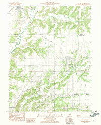
1983 Map of Beecher City
USGS Topo · Published 1983About this map
The Kaskaskia River snakes through the northwest corner of this Illinois landscape, defining a border between Shelby and Fayette counties. This region, captured in the early 1980s, is characterized by a dense network of rural infrastructure supporting both agriculture and the Loudon Oil Field. The village of Beecher City serves as a central hub, connected by the Baltimore and Ohio railroad line which cuts diagonally through the townships of Liberty and Moccasin.
Find a feature on this map
42 named features on this map. Tap any name to fly to it.
Don’t see what you’re looking for? This feature index may not catch every label — zoom into the map to look around manually.
Map Details
Editions of this 1983 Beecher City Map
This is the sole edition of this map. No revisions or reprints were ever made.
Other maps of this area

1941 · St. Elmo
USGS Topo · 1:62,500

1942 · Shelbyville
USGS Topo · 1:62,500

1945 · St. Elmo
USGS Topo · 1:62,500

1946 · Shelbyville
USGS Topo · 1:62,500

1947 · Stewardson
USGS Topo · 1:62,500

1949 · Stewardson
USGS Topo · 1:62,500

1950 · Effingham
USGS Topo · 1:62,500

1951 · Effingham
USGS Topo · 1:62,500

1958 · Decatur
USGS Topo · 1:250,000

1961 · Decatur
USGS Topo · 1:250,000