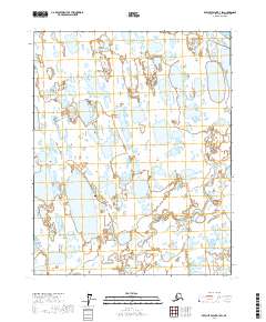
2017 Map of Beechey Point B-3 SW
USGS Topo · Published 2017About this map
Alaska Pipeline infrastructure cuts through this northern landscape, marking a significant industrial corridor on the North Slope. The terrain is defined by an intricate network of coastal wetlands and thermokarst lakes, draining toward the Stefansson Sound at the northern edge. Inland, the Putuligayuk River meanders across the low-lying tundra, accompanied by smaller tributaries such as Fawn Cr. A rare point of vertical relief is found at Kuparuk Mound, a distinctive landmark in an otherwise exceptionally flat coastal plain. This 2017 survey captures the intersection of critical energy infrastructure and the delicate Arctic hydrologic system, where seasonal water flow and frozen ground dictate the character of the environment.
Find a feature on this map
11 named features on this map. Tap any name to fly to it.
Don’t see what you’re looking for? This feature index may not catch every label — zoom into the map to look around manually.
Map Details
Editions of this 2017 Beechey Point B-3 SW Map
This is the sole edition of this map. No revisions or reprints were ever made.
Other maps of this area

1951 · Beechey Point
USGS Topo · 1:250,000

1955 · Beechey Point
USGS Topo · 1:250,000

1955 · Beechey Point B-4
USGS Topo · 1:63,360

1955 · Beechey Point A-3
USGS Topo · 1:63,360

1955 · Beechey Point A-4
USGS Topo · 1:63,360

1955 · Beechey Point B-3
USGS Topo · 1:63,360

1960 · Beechey Point
USGS Topo · 1:250,000

1962 · Beechey Point B-4
USGS Topo · 1:50,000

1964 · Beechey Point
USGS Topo · 1:250,000
1970 · Beechey Point A-4 NE
USGS Topo · 1:24,000