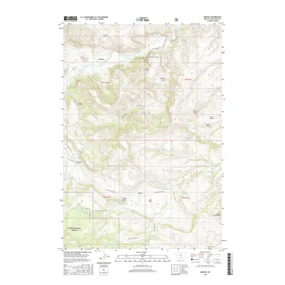
2017 Map of Beehive
USGS Topo · Published 2017About this map
Custer National Forest dominates the southern reaches of this Montana landscape, where the high country transitions into the valley of the Stillwater River. The small settlement of Beehive sits near the river's edge, overshadowed by the prominent Beehive Rock and the deep incisions of Bad Canyon. Further south, the community of Dean marks a transition point between the open Dean Basin and the rising peaks of the Beartooth range.
Find a feature on this map
44 named features on this map. Tap any name to fly to it.
Don’t see what you’re looking for? This feature index may not catch every label — zoom into the map to look around manually.
Map Details
Editions of this 2017 Beehive Map
This is the sole edition of this map. No revisions or reprints were ever made.
Other maps of this area

1891 · Big Timber
USGS Topo · 1:125,000

1893 · Big Timber
USGS Topo · 1:125,000

1898 · Granite Mountain District
USGS Topo · 1:125,000

1932 · Nye No 1
USGS Topo · 1:48,000

1932 · Nye No 2
USGS Topo · 1:48,000

1939 · Mt Wood
USGS Topo · 1:62,500

1941 · Mt. Wood
USGS Topo · 1:62,500

1954 · Billings
USGS Topo · 1:250,000

1955 · Sandborn Creek
USGS Topo · 1:24,000
1955 · Wildcat Draw
USGS Topo · 1:24,000