
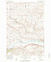
1955 Map of Sandborn Creek
USGS Topo · Published 1957About this map
The Stillwater River valley in South Central Montana is defined here by a sophisticated network of irrigation systems developed in the mid-20th century. The intricate placement of the Weir-Crawford Ditch, Mendenhall Ditch, and Tintinger Ditch illustrates the vital water management required for ranching and agriculture along the riverbanks. To the south, Fladberg Bench rises above the valley floor, while the landscape is dotted with small-scale rural infrastructure like Spring Creek Sch and Kent Lake Sch. These schoolhouses, along with family-named features like the Phelps Ditch and Brey Riddle Ditch, provide specific touchstones for genealogists tracing local families during this era of rural development. The map also captures several major drainages, including Jack Stone Creek and Countryman Creek, which cut through the hills of the Sweet Grass and Stillwater county border.
Find a feature on this map
25 named features on this map. Tap any name to fly to it.
Don’t see what you’re looking for? This feature index may not catch every label — zoom into the map to look around manually.
Map Details
Editions of this 1955 Sandborn Creek Map
2 editions found
Other maps of this area

1891 · Big Timber
USGS Topo · 1:125,000

1892 · Stillwater
USGS Topo · 1:125,000

1893 · Big Timber
USGS Topo · 1:125,000

1898 · Granite Mountain District
USGS Topo · 1:125,000

1932 · Red Lodge No 2
USGS Topo · 1:48,000

1932 · Nye No 1
USGS Topo · 1:48,000

1954 · Billings
USGS Topo · 1:250,000

1955 · Reed Point
USGS Topo · 1:24,000

1955 · Springtime
USGS Topo · 1:24,000

1955 · Absarokee
USGS Topo · 1:24,000