
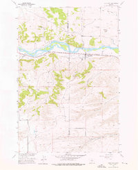
1955 Map of Reed Point
USGS Topo · Published 1957About this map
The Yellowstone River cuts a wide path through this mid-century landscape, defining the boundary and economic life of the valley. Along the southern bank, the Northern Pacific railroad and irrigation infrastructure like the Reed Point Ditch and Kent Ditch demonstrate the essential marriage of transport and water management in the region. The settlement of Reed Point serves as the focal point, supported by local landmarks such as the Reed Point Cem and the White Beaver Sch to the northwest. To the south, the terrain rises toward Monument Butte, where the landscape becomes more dissected by drainages like H M Creek and the forks of Countryman Creek. This 1955 survey captures the transition from the river-bottom agriculture and rail operations at the Sectionhouse to the high, open ranching country on the border of Sweet Grass and Stillwater counties.
Find a feature on this map
20 named features on this map. Tap any name to fly to it.
Don’t see what you’re looking for? This feature index may not catch every label — zoom into the map to look around manually.
Map Details
Editions of this 1955 Reed Point Map
2 editions found
Other maps of this area

1891 · Big Timber
USGS Topo · 1:125,000

1892 · Stillwater
USGS Topo · 1:125,000

1893 · Big Timber
USGS Topo · 1:125,000

1954 · Billings
USGS Topo · 1:250,000

1955 · Antelope Point
USGS Topo · 1:24,000

1955 · Sandborn Creek
USGS Topo · 1:24,000

1955 · Springtime
USGS Topo · 1:24,000

1955 · Absarokee
USGS Topo · 1:24,000
1955 · Cow Face Hill
USGS Topo · 1:24,000

1955 · Stephens Hill
USGS Topo · 1:24,000