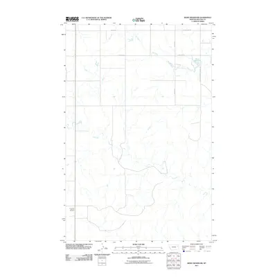
2011 Map of Beery Reservoir
USGS Topo · Published 2011About this map
Hay Creek and Cow Creek carve through the open range of McCone County, defining a landscape dominated by large-scale ranching and water management in the early 21st century. The map highlights the localized infrastructure of the Montana plains, where water features like the Beery Reservoir are central to the region's agricultural utility. Grounded in the local history of the area, the Immanuel Lutheran Cemetery serves as a lone landmark in the southwest, anchoring the map's genealogical value to early settlers of this prairie country. The road network, including the specifically named Beerys Land and Live-Stock Rd and Sunrise Rd, reflects the enduring legacy of family ranching operations. Modern transit is represented by Mount Hwy 254 and Richey Rd, which provide the primary connectivity across this sparsely populated section of the High Plains.
Find a feature on this map
10 named features on this map. Tap any name to fly to it.
Don’t see what you’re looking for? This feature index may not catch every label — zoom into the map to look around manually.
Map Details
Editions of this 2011 Beery Reservoir Map
This is the sole edition of this map. No revisions or reprints were ever made.
Other maps of this area

1954 · Glendive
USGS Topo · 1:250,000

1957 · Glendive
USGS Topo · 1:250,000

1958 · Glendive
USGS Topo · 1:250,000

1983 · Hudiburgh Reservoir
USGS Topo · 1:24,000

1983 · Buffalo Creek NE
USGS Topo · 1:24,000
1983 · Kraut Coulee
USGS Topo · 1:24,000

1983 · Buffalo Creek
USGS Topo · 1:24,000

1983 · Beery Reservoir
USGS Topo · 1:24,000
1983 · Lone Pine School
USGS Topo · 1:24,000
1983 · Buffalo Creek SE
USGS Topo · 1:24,000