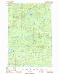
1989 Map of Beetle Mountain
USGS Topo · Published 1989About this map
Reed Mountain and Beetle Mountain anchor this 1989 survey of the Maine North Woods, a landscape defined by an intricate network of remote water bodies and timberland terrain. The map captures a wilderness area organized by the township and range system, specifically covering portions of T8 R11 W E L S and its neighbors. A significant drainage system is visible, dominated by the elongated Chandler Pond and the meandering East Branch Deadwater, which feeds toward the Moose River. Smaller, isolated ponds like Blackmore Pond and Pretty Pond are scattered among the ridges, reflecting the glacially-carved geography of Piscataquis County. This edition is particularly useful for tracking the primitive road and trail networks used by foresters and sportsmen during the late twentieth century, including routes near Bluffer Ridge and the South Ridge.
Find a feature on this map
39 named features on this map. Tap any name to fly to it.
Don’t see what you’re looking for? This feature index may not catch every label — zoom into the map to look around manually.
Map Details
Editions of this 1989 Beetle Mountain Map
This is the sole edition of this map. No revisions or reprints were ever made.
Other maps of this area

1953 · Telos Lake
USGS Topo · 1:62,500

1954 · Spider Lake
USGS Topo · 1:62,500

1954 · Millinocket Lake
USGS Topo · 1:62,500

1954 · Presque Isle
USGS Topo · 1:250,000

1955 · Traveler Mountain
USGS Topo · 1:62,500

1957 · Telos Lake
USGS Topo · 1:62,500

1958 · Presque Isle
USGS Topo · 1:250,000

1960 · Presque Isle
USGS Topo · 1:250,000

1961 · Spider Lake
USGS Topo · 1:62,500
1975 · Traveler Mountain NW
USGS Topo · 1:24,000