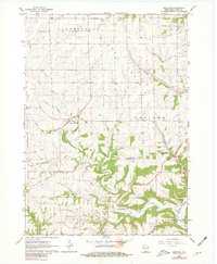
1962 Map of Beetown
USGS Topo · Published 1981About this map
Beetown and North Andover anchor this rural landscape in western Grant County, where the topography is defined by the winding course of the Grant River and its numerous tributaries. The map reveals a deeply etched drainage pattern, with Rattlesnake Creek and Muskellunge Creek carving through the terrain. A notable density of local history markers is evident through the scattered cemeteries that served these early agricultural communities, including Blake Prairie Cem, Providence Cem, and St Marys Cem. The map's detail extends to the economic foundations of the area, showing several quarries and mines near Beetown, reflecting the region's long-standing connection to lead and stone extraction. Educational roots are also preserved in landmarks like the Flat Rock Sch near Flat Rock Creek, illustrating the decentralized social structure of the early 1960s.
Find a feature on this map
29 named features on this map. Tap any name to fly to it.
Don’t see what you’re looking for? This feature index may not catch every label — zoom into the map to look around manually.
Map Details
Editions of this 1962 Beetown Map
2 editions found
Other maps of this area

1900 · Lancaster
USGS Topo · 1:125,000

1902 · Elkader
USGS Topo · 1:125,000

1904 · Lancaster
USGS Topo · 1:125,000

1908 · Lancaster
USGS Topo · 1:125,000

1955 · Cassville
USGS Topo · 1:24,000

1955 · Balltown
USGS Topo · 1:24,000

1957 · Turkey River
USGS Topo · 1:24,000

1959 · Dubuque
USGS Topo · 1:250,000

1961 · Dubuque
USGS Topo · 1:250,000

1962 · Dubuque
USGS Topo · 1:250,000