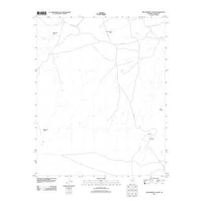
2011 Map of Begashibito Canyon
USGS Topo · Published 2011About this map
Behihlih sits near the southeastern edge of this high desert landscape, positioned near the Blue Canyon Trading Post and the dramatic geological formation of Blue Canyon. The terrain is defined by a network of drainage systems, including Begashibito Wash and Bitter Spring Wash, which cut through the arid plateaus of the Navajo Nation. These washes are punctuated by vital water sources such as Bitter Spring, Coldwater Spring, and Wild Horse Spring, which have historically dictated the patterns of movement and settlement in this corner of Coconino County.
Find a feature on this map
15 named features on this map. Tap any name to fly to it.
Don’t see what you’re looking for? This feature index may not catch every label — zoom into the map to look around manually.
Map Details
Editions of this 2011 Begashibito Canyon Map
This is the sole edition of this map. No revisions or reprints were ever made.
Other maps of this area

1883 · Marsh Pass
USGS Topo · 1:250,000

1886 · Echo Cliffs
USGS Topo · 1:250,000

1891 · Echo Cliffs
USGS Topo · 1:250,000

1892 · Marsh Pass
USGS Topo · 1:250,000

1956 · Marble Canyon
USGS Topo · 1:250,000

1959 · Marble Canyon
USGS Topo · 1:250,000

1961 · Marble Canyon
USGS Topo · 1:250,000
1967 · Bat Spring
USGS Topo · 1:24,000
1967 · Pillars of Hercules
USGS Topo · 1:24,000
1967 · Bat Canyon
USGS Topo · 1:24,000