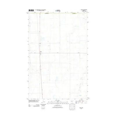
2013 Map of Bejou
USGS Topo · Published 2013About this map
Bejou serves as a central hub in this agricultural landscape near the boundary between Polk Co and Mahnomen Co. The settlement is defined by the intersection of Us-59 and Co Hwy-1, with a local street grid including Roosevelt Ave and a central Po. The surrounding terrain is characterized by prairie wetlands and small water bodies, notably Twin Oaks Lake in the southeast and the winding course of Marsh Cr, which snakes through the northern and western sections of the quadrangle. Local heritage is grounded at the Bejou Cem, located just north of the town center. This survey captures the rural infrastructure of northwestern Minnesota in the early twenty-first century, showing a high concentration of small sloughs and depressions typical of the regional geography.
Find a feature on this map
9 named features on this map. Tap any name to fly to it.
Don’t see what you’re looking for? This feature index may not catch every label — zoom into the map to look around manually.
Map Details
Editions of this 2013 Bejou Map
This is the sole edition of this map. No revisions or reprints were ever made.
Other maps of this area

1919 · Valley
USGS Topo · 1:62,500

1952 · Grand Forks
USGS Topo · 1:250,000

1954 · Bemidji
USGS Topo · 1:250,000

1956 · Grand Forks
USGS Topo · 1:250,000

1957 · Bemidji
USGS Topo · 1:250,000

1958 · Bemidji
USGS Topo · 1:250,000

1966 · Grand Forks
USGS Topo · 1:250,000

1966 · Union Lake
USGS Topo · 1:24,000
1966 · Faith
USGS Topo · 1:24,000
1966 · Faith NE
USGS Topo · 1:24,000