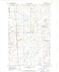
1969 Map of Bejou
USGS Topo · Published 1972About this map
The Soo Line railroad forms a sharp north-south axis through this portion of Mahnomen County, passing directly through the small settlement of Bejou. This 1969 field check reveals a landscape heavily managed for conservation, dominated by a large network of protected lands including the Bejou State Wildlife Management Area, Loncrace State Wildlife Management Area, and Gregory State Wildlife Management Area. The area sits at the White Earth Indian Reservation Boundary, where the prairie-like terrain is crisscrossed by drainage infrastructure such as Judicial Ditch No 91. Local history is anchored by the Bejou Cem and a solitary Townhall in the southwest, while the eastern edge contains small water bodies like Church Lake and Twin Oaks Lake. The map illustrates a rural economy shifting toward wildlife preservation while maintaining traditional transit corridors.
Find a feature on this map
24 named features on this map. Tap any name to fly to it.
Don’t see what you’re looking for? This feature index may not catch every label — zoom into the map to look around manually.
Map Details
Editions of this 1969 Bejou Map
This is the sole edition of this map. No revisions or reprints were ever made.
Other maps of this area

1919 · Valley
USGS Topo · 1:62,500

1952 · Grand Forks
USGS Topo · 1:250,000

1954 · Bemidji
USGS Topo · 1:250,000

1956 · Grand Forks
USGS Topo · 1:250,000

1957 · Bemidji
USGS Topo · 1:250,000

1958 · Bemidji
USGS Topo · 1:250,000

1966 · Grand Forks
USGS Topo · 1:250,000

1966 · Union Lake
USGS Topo · 1:24,000
1966 · Faith
USGS Topo · 1:24,000
1966 · Faith NE
USGS Topo · 1:24,000