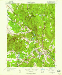
1949 Map of Belchertown
USGS Topo · Published 1958About this map
Belchertown and its surrounding rural hamlets are centered in a landscape of rolling peaks and intricate water systems in mid-century Massachusetts. The region is defined by a cluster of lakes such as Arcadia Lake, Metacomet Lake, and Lake Holland, which are tied together by the rugged Metacomet Trail. Local infrastructure is anchored by the Central Vermont and Boston and Maine railroads, which facilitated movement through established stops like Dwight.
Find a feature on this map
61 named features on this map. Tap any name to fly to it.
Don’t see what you’re looking for? This feature index may not catch every label — zoom into the map to look around manually.
Map Details
Editions of this 1949 Belchertown Map
2 editions found
Other maps of this area

1885 · Northampton
USGS Topo · 1:62,500

1886 · Springfield
USGS Topo · 1:62,500

1886 · Northampton
USGS Topo · 1:62,500

1887 · Palmer
USGS Topo · 1:62,500

1887 · Belchertown
USGS Topo · 1:62,500

1889 · Springfield
USGS Topo · 1:62,500

1889 · Palmer
USGS Topo · 1:62,500

1890 · Belchertown
USGS Topo · 1:62,500

1891 · Northampton
USGS Topo · 1:62,500

1893 · Northampton
USGS Topo · 1:62,500