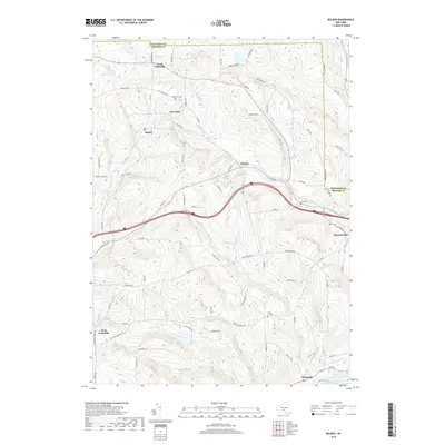
2019 Map of Belden
USGS Topo · Published 2019About this map
Harpursville and the surrounding township of Colesville are defined by a complex network of creeks and small upland settlements in this modern survey. The geography is shaped by the winding Susquehanna River in the southeast corner and the many tributaries that feed it, including Still Creek, Belden Brook, and Ouaquaga Cr. The map documents a landscape of high ridges and narrow valleys, where rural life is anchored by locations like New Ohio and Tunnel. Local family history is preserved at sites such as New Ohio Cem, Pratt Cem, and Coles Hill Cem. The infrastructure follows the natural topography, with roads like Death Valley Rd and Farm to Market Rd connecting disparate clusters of homes. This detailed record illustrates the enduring rural character of Broome County, showing how historical hamlets like North Colesville and Belden persist within the modern roadway system.
Find a feature on this map
77 named features on this map. Tap any name to fly to it.
Don’t see what you’re looking for? This feature index may not catch every label — zoom into the map to look around manually.
Map Details
Editions of this 2019 Belden Map
This is the sole edition of this map. No revisions or reprints were ever made.
Other maps of this area

1902 · Coventry
USGS Topo · 1:62,500

1904 · Binghamton
USGS Topo · 1:62,500

1904 · Greene
USGS Topo · 1:62,500

1904 · Oxford
USGS Topo · 1:62,500

1905 · Nineveh
USGS Topo · 1:62,500

1935 · Chenango Forks
USGS Topo · 1:24,000

1937 · Binghamton East
USGS Topo · 1:24,000

1942 · Chenango Forks
USGS Topo · 1:31,680

1942 · Binghamton East
USGS Topo · 1:31,680
1948 · Greene
USGS Topo · 1:24,000