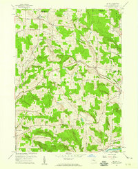
1957 Map of Belden
USGS Topo · Published 1959About this map
North Colesville and the surrounding township of Colesville are defined by a network of rural roads and the heavy influence of the Delaware and Hudson railroad in the late 1950s. The terrain transitions from the high elevations of Beartown Hill down toward the Susquehanna River valley in the southeast. This survey highlights the region's mid-century transportation and aviation infrastructure, from the railroad Tunnel to the Harmony Crest Airfield. Local genealogy is well-supported by the inclusion of several burial grounds, such as New Ohio Cem, Pratts Cem, and Coles Hill Cem. The map also captures specific recreational and industrial sites like the Belden Hill Golf Course and a local Quarry, reflecting the diverse land use in eastern Broome County during this era.
Find a feature on this map
38 named features on this map. Tap any name to fly to it.
Don’t see what you’re looking for? This feature index may not catch every label — zoom into the map to look around manually.
Map Details
Editions of this 1957 Belden Map
This is the sole edition of this map. No revisions or reprints were ever made.
Other maps of this area

1902 · Coventry
USGS Topo · 1:62,500

1904 · Binghamton
USGS Topo · 1:62,500

1904 · Greene
USGS Topo · 1:62,500

1904 · Oxford
USGS Topo · 1:62,500

1905 · Nineveh
USGS Topo · 1:62,500

1935 · Chenango Forks
USGS Topo · 1:24,000

1937 · Binghamton East
USGS Topo · 1:24,000

1942 · Chenango Forks
USGS Topo · 1:31,680

1942 · Binghamton East
USGS Topo · 1:31,680
1948 · Greene
USGS Topo · 1:24,000