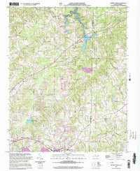
2000 Map of Belews Creek
USGS Topo · Published 2003About this map
Kernersville and its surrounding countryside are captured here in a transition between rural tradition and suburban development at the turn of the millennium. The landscape is defined by the headwaters of the Haw River and the extensive waters of Belews Lake, which straddles the county line. The map reveals a high density of rural religious centers, including Antioch Ch, White Road Ch, and Shining Light Ch, which often serve as the focal points for small communities like Crims Crossroads.
Find a feature on this map
42 named features on this map. Tap any name to fly to it.
Don’t see what you’re looking for? This feature index may not catch every label — zoom into the map to look around manually.
Map Details
Editions of this 2000 Belews Creek Map
This is the sole edition of this map. No revisions or reprints were ever made.
Other maps of this area

1950 · Winston-Salem East
USGS Topo · 1:24,000

1951 · Winston-Salem East
USGS Topo · 1:24,000

1951 · Guilford
USGS Topo · 1:24,000

1951 · Walkertown
USGS Topo · 1:24,000

1953 · Winston-Salem
USGS Topo · 1:250,000

1953 · Greensboro
USGS Topo · 1:250,000

1954 · Greensboro
USGS Topo · 1:250,000

1955 · Winston-Salem
USGS Topo · 1:250,000

1962 · Winston-Salem
USGS Topo · 1:250,000

1962 · Greensboro
USGS Topo · 1:250,000