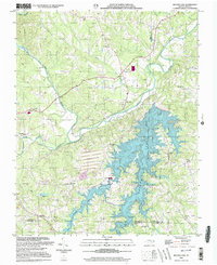
2000 Map of Belews Lake
USGS Topo · Published 2003About this map
Belews Lake dominates the southern landscape of this Piedmont quadrangle where the borders of Stokes, Rockingham, Forsyth, and Guilford counties converge. The reservoir's irregular shoreline is defined by flooded valleys once carved by Belews Creek and West Belews Creek, now supporting a modern Powerplant and significant infrastructure including a large Tailings Pond and multiple substations. The industrial character of the area is balanced by long-standing rural settlements, notably Pine Hall to the north, situated along the Dan River.
Find a feature on this map
33 named features on this map. Tap any name to fly to it.
Don’t see what you’re looking for? This feature index may not catch every label — zoom into the map to look around manually.
Map Details
Editions of this 2000 Belews Lake Map
This is the sole edition of this map. No revisions or reprints were ever made.
Other maps of this area

1951 · Walkertown
USGS Topo · 1:24,000

1953 · Winston-Salem
USGS Topo · 1:250,000

1953 · Greensboro
USGS Topo · 1:250,000

1954 · Greensboro
USGS Topo · 1:250,000

1955 · Winston-Salem
USGS Topo · 1:250,000

1962 · Winston-Salem
USGS Topo · 1:250,000

1962 · Greensboro
USGS Topo · 1:250,000

1966 · Greensboro
USGS Topo · 1:250,000

1969 · Summerfield
USGS Topo · 1:24,000

1969 · Belews Creek
USGS Topo · 1:24,000