
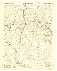
1936 Map of Belfast
USGS Topo · Published 1936About this map
The Belfast community and nearby Farmington anchor this rural landscape during a period of transition in Middle Tennessee. The Nashville Chattanooga and St Louis railroad line cuts through the center of the sheet, serving as a primary corridor for commerce and travel between small agrarian settlements. The terrain is defined by the prominent Elk Ridge to the south and the Elk River Valley, with numerous waterways like Belfast Creek and Rock Creek draining the limestone-rich soils.
Find a feature on this map
43 named features on this map. Tap any name to fly to it.
Don’t see what you’re looking for? This feature index may not catch every label — zoom into the map to look around manually.
Map Details
Editions of this 1936 Belfast Map
This is the sole edition of this map. No revisions or reprints were ever made.
Other maps of this area

1936 · Farmington
USGS Topo · 1:24,000

1936 · Cornersville
USGS Topo · 1:24,000

1936 · Lewisburg
USGS Topo · 1:24,000

1936 · Belleville
USGS Topo · 1:24,000

1936 · Verona
USGS Topo · 1:24,000

1936 · Petersburg
USGS Topo · 1:24,000

1936 · Unionville
USGS Topo · 1:24,000

1936 · Bedford
USGS Topo · 1:24,000

1944 · Shelbyville
USGS Topo · 1:100,000
1947 · Farmington
USGS Topo · 1:24,000