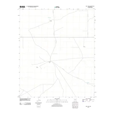
2010 Map of Bell Lake
USGS Topo · Published 2010About this map
Bell Lake and its namesake Bell Lake Windmill anchor this high desert landscape in Lea County, illustrating the vital role of water infrastructure in the arid Chihuahuan Desert. The map reveals a remote ranching economy defined by isolated outposts and wind-powered water sources. The Double X Ranch serves as a central hub for the area's movement, situated at the junction of several unpaved transit routes including County Rd 2. Evidence of the region's industrial and agricultural reliance on groundwater is visible through clusters of features like the Slick Windmills to the east and the Pipeline Windmill to the southwest. Surface water is sparse, with Red Tank representing one of the few named catchment features in the southeastern portion of the quadrangle. This 2010 survey documents a landscape where modern infrastructure and traditional ranching life intersect along roads such as Brinstool Rd.
Find a feature on this map
9 named features on this map. Tap any name to fly to it.
Don’t see what you’re looking for? This feature index may not catch every label — zoom into the map to look around manually.
Map Details
Editions of this 2010 Bell Lake Map
This is the sole edition of this map. No revisions or reprints were ever made.
Other maps of this area

1954 · Hobbs
USGS Topo · 1:250,000

1958 · Hobbs
USGS Topo · 1:250,000

1963 · Oil Center
USGS Topo · 1:62,500

1963 · Hat Mesa
USGS Topo · 1:62,500

1973 · Bell Lake
USGS Topo · 1:24,000

1973 · Paduca Breaks NW
USGS Topo · 1:24,000

1973 · Paduca Breaks East
USGS Topo · 1:24,000
1973 · Paduca Breaks West
USGS Topo · 1:24,000
1973 · Andrews Place
USGS Topo · 1:24,000
1973 · Woodley Flat
USGS Topo · 1:24,000