
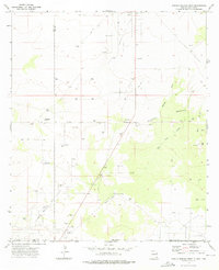
1973 Map of Paduca Breaks East
USGS Topo · Published 1976About this map
The Salado Draw Oil Field and El Mar Oil Field dominate this desert landscape straddling the New Mexico-Texas border in the early 1970s. Industrial development is heavy throughout the terrain, marked by a dense network of drill holes, pipelines, and gas wells that intersect the arid topography. The map reveals the critical infrastructure of the era's energy sector, including various gravel pits and a jeep trail that provided access to the remote drilling sites.
Find a feature on this map
27 named features on this map. Tap any name to fly to it.
Don’t see what you’re looking for? This feature index may not catch every label — zoom into the map to look around manually.
Map Details
Editions of this 1973 Paduca Breaks East Map
This is the sole edition of this map. No revisions or reprints were ever made.
Other maps of this area

1954 · Hobbs
USGS Topo · 1:250,000

1954 · Pecos
USGS Topo · 1:250,000

1957 · Pecos
USGS Topo · 1:250,000

1958 · Hobbs
USGS Topo · 1:250,000

1969 · Kyle Ranch
USGS Topo · 1:24,000

1969 · Rudd Draw NE
USGS Topo · 1:24,000

1970 · Brunson Ranch
USGS Topo · 1:24,000

1973 · Bell Lake
USGS Topo · 1:24,000

1973 · Paduca Breaks NW
USGS Topo · 1:24,000
1973 · Paduca Breaks West
USGS Topo · 1:24,000