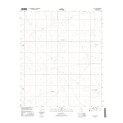
2017 Map of Bell Lake
USGS Topo · Published 2017About this map
Bell Lake centers this landscape in eastern Lea County, where the high desert terrain is defined by isolated water sources and a network of rural roads. This 2017 survey illustrates the sparse but critical infrastructure of the region, where roads like Brinstool Rd and Vaca Ln connect remote tracts. The presence of water features such as Jog Tank and Red Tank among the township and range lines of t24s r33e indicates the area's historical reliance on managed water for ranching or industrial use. The map provides a precise layout of section boundaries and local access routes, including Resource Ln and Co Rd 2, revealing the organized division of this corner of New Mexico during the early 21st century.
Find a feature on this map
15 named features on this map. Tap any name to fly to it.
Don’t see what you’re looking for? This feature index may not catch every label — zoom into the map to look around manually.
Map Details
Editions of this 2017 Bell Lake Map
This is the sole edition of this map. No revisions or reprints were ever made.
Other maps of this area

1954 · Hobbs
USGS Topo · 1:250,000

1958 · Hobbs
USGS Topo · 1:250,000

1963 · Oil Center
USGS Topo · 1:62,500

1963 · Hat Mesa
USGS Topo · 1:62,500

1973 · Bell Lake
USGS Topo · 1:24,000

1973 · Paduca Breaks NW
USGS Topo · 1:24,000

1973 · Paduca Breaks East
USGS Topo · 1:24,000
1973 · Paduca Breaks West
USGS Topo · 1:24,000
1973 · Andrews Place
USGS Topo · 1:24,000
1973 · Woodley Flat
USGS Topo · 1:24,000