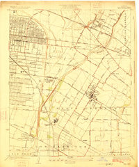
1925 Map of Bell
USGS Topo · Published 1925About this map
Rio Hondo and the Los Angeles River define this corner of the Los Angeles basin during the mid-1920s, a period of rapid industrial and residential transition. While much of the land remains divided by early ranchos like Santa Gertrudis and Los Cerritos, the emergence of the Rio Grande Oil Refinery and extensive rail networks mark the era's shift toward heavy industry. Numerous small settlements and station stops such as Cudahy Sta, Viñvale, and South Gate are already plotted with dense street grids, while the County Farm Hondo PO serves as a prominent local landmark.
Find a feature on this map
85 named features on this map. Tap any name to fly to it.
Don’t see what you’re looking for? This feature index may not catch every label — zoom into the map to look around manually.
Map Details
Editions of this 1925 Bell Map
2 editions found
Other maps of this area

1894 · Los Angeles
USGS Topo · 1:62,500

1896 · Pasadena
USGS Topo · 1:62,500

1896 · Downey
USGS Topo · 1:62,500

1899 · Downey
USGS Topo · 1:62,500

1900 · Pasadena
USGS Topo · 1:62,500

1900 · Los Angeles
USGS Topo · 1:62,500

1901 · Southern California Sheet No. 1
USGS Topo · 1:250,000

1902 · Downey
USGS Topo · 1:62,500

1904 · Southern California Sheet No. 1
USGS Topo · 1:250,000
1923 · Bell
USGS Topo · 1:24,000