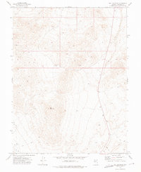
1972 Map of Bell Mountain
USGS Topo · Published 1975About this map
Bell Mountain dominates this Churchill County landscape, rising from the basin floor as a central topographic fixture in the early 1970s. The terrain transitions into the wide expanse of Bell Flat to the southwest, a region defined more by its natural contours than by permanent settlement. The presence of a marked Mine and several scattered Prospects in the northern ridges indicates the historical interest in mineral extraction that often drove Nevada's high-desert exploration. Movement through this arid environment is recorded by several segments of Jeep Trail, illustrating the rugged, off-road access typical of the Great Basin's interior ranges during this era. This survey, compiled from 1971 aerial photography, captures the intersection of resource scouting and the persistent isolation of the Nevada desert.
Find a feature on this map
7 named features on this map. Tap any name to fly to it.
Don’t see what you’re looking for? This feature index may not catch every label — zoom into the map to look around manually.
Map Details
Editions of this 1972 Bell Mountain Map
This is the sole edition of this map. No revisions or reprints were ever made.
Other maps of this area

1908 · Carson Sink
USGS Topo · 1:250,000

1910 · Carson Sink
USGS Topo · 1:250,000

1955 · Millett
USGS Topo · 1:250,000

1957 · Reno
USGS Topo · 1:250,000

1959 · Reno
USGS Topo · 1:250,000

1959 · Millett
USGS Topo · 1:250,000

1960 · Reno
USGS Topo · 1:250,000
1969 · Quartz Mtn
USGS Topo · 1:24,000
1969 · Quartzite Mtn NW
USGS Topo · 1:24,000

1969 · Eastgate
USGS Topo · 1:24,000