
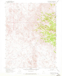
1969 Map of Eastgate
USGS Topo · Published 1972About this map
The Clan Alpine Mountains dominate the western horizon of this high-desert landscape in Churchill County, where the settlement of Eastgate and the junction at Middlegate served as vital points of passage through the Great Basin. Surveyed in the late 1960s, the map reveals a history of resource extraction and water management in an arid environment. The eastern slopes of the range are marked by the Eastgate Mine and Double Eagle Mine, while numerous prospects suggest the continuous search for mineral wealth. Water is the defining constraint of this terrain, anchored by White Rock Springs and the drainage of Eastgate Wash. The presence of unnamed Ruins and a Gaging Station near the road junction illustrates the intersection of earlier settlement patterns with modern hydrologic monitoring. Tracing the path of Bench Creek and Rock Creek provides insight into how topography dictated the development of transportation and land use in this isolated Nevada corridor.
Find a feature on this map
28 named features on this map. Tap any name to fly to it.
Don’t see what you’re looking for? This feature index may not catch every label — zoom into the map to look around manually.
Map Details
Editions of this 1969 Eastgate Map
This is the sole edition of this map. No revisions or reprints were ever made.
Other maps of this area

1908 · Carson Sink
USGS Topo · 1:250,000

1910 · Carson Sink
USGS Topo · 1:250,000

1955 · Millett
USGS Topo · 1:250,000

1957 · Reno
USGS Topo · 1:250,000

1959 · Reno
USGS Topo · 1:250,000

1959 · Millett
USGS Topo · 1:250,000

1960 · Reno
USGS Topo · 1:250,000

1969 · Camp Creek Canyon
USGS Topo · 1:24,000
1969 · Quartzite Mtn NW
USGS Topo · 1:24,000

1969 · Cold Springs
USGS Topo · 1:24,000