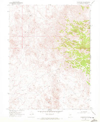
1969 Map of Quartzite Mtn NW
USGS Topo · Published 1972About this map
The Broken Hills dominate this portion of Churchill County, revealing a landscape defined by the search for water and mineral wealth in the late 1960s. Surveyed by the Geological Survey, the area is crisscrossed by a network of Jeep Trails that link remote outposts and hydrological markers. Evidence of the region’s ranching or industrial utility is found at Grayback Well No 1 and the labeled Grayback Well No 2 (Dry), alongside the natural source at Mud Spring. The terrain is marked by distinctive formations like Iron Rock and the elevations of Grayback, while scattered Prospect labels indicate the persistent exploratory mining common in this Nevada corridor. The scarcity of permanent settlements emphasizes the demanding nature of the environment during this era of mapping.
Find a feature on this map
9 named features on this map. Tap any name to fly to it.
Don’t see what you’re looking for? This feature index may not catch every label — zoom into the map to look around manually.
Map Details
Editions of this 1969 Quartzite Mtn NW Map
3 editions found
Other maps of this area

1908 · Carson Sink
USGS Topo · 1:250,000

1910 · Carson Sink
USGS Topo · 1:250,000

1955 · Millett
USGS Topo · 1:250,000

1957 · Reno
USGS Topo · 1:250,000

1959 · Reno
USGS Topo · 1:250,000

1959 · Millett
USGS Topo · 1:250,000

1960 · Reno
USGS Topo · 1:250,000
1969 · Quartz Mtn
USGS Topo · 1:24,000

1969 · Desatoya Peak
USGS Topo · 1:24,000

1969 · Eastgate
USGS Topo · 1:24,000