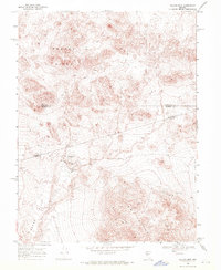
1969 Map of Quartz Mtn
USGS Topo · Published 1971About this map
Broken Hills and the adjacent arid basins define this high-desert territory where Mineral, Nye, and Churchill counties meet. Recorded in the late 1960s, the landscape is primarily shaped by silver and lead mining interests clustered near the center of the sheet. The settlement of Quartz Mountain is shown alongside Quartz Mountain (Site), suggesting a shift in local habitation patterns or the relocation of a community center over time. To the south, several established workings such as the San Rafael Mine and Hasbrouck Mine occupy the slopes above Gabbs Valley. The map also traces a network of remote transportation routes, including a Jeep Trail and various unpaved paths connecting the Huntley Mine and White Pine Mine to the broader Lodi Valley.
Find a feature on this map
13 named features on this map. Tap any name to fly to it.
Don’t see what you’re looking for? This feature index may not catch every label — zoom into the map to look around manually.
Map Details
Editions of this 1969 Quartz Mtn Map
3 editions found
Other maps of this area

1907 · Tonopah
USGS Topo · 1:250,000

1908 · Tonopah
USGS Topo · 1:250,000

1908 · Carson Sink
USGS Topo · 1:250,000

1909 · Hawthorne
USGS Topo · 1:250,000

1910 · Carson Sink
USGS Topo · 1:250,000

1911 · Hawthorne
USGS Topo · 1:250,000

1915 · Hawthorne
USGS Topo · 1:250,000

1948 · Paradise Peak
USGS Topo · 1:62,500

1948 · Walker Lake
USGS Topo · 1:250,000

1950 · Paradise Peak
USGS Topo · 1:62,500