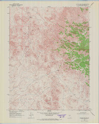
1969 Map of Quartz Mtn NW
USGS Topo · Published 1972About this map
Broken Hills and the Grayback range dominate this 1969 topographical study of Churchill County, capturing a remote landscape defined by its scarce water sources and mineral potential. The map reveals the vital infrastructure of the high desert, where deep wells like Grayback Well No 1 and the notably Grayback Well No 2 (Dry) provided essential support for ranching or prospecting. A thin network of Jeep Trails snakes through the terrain, connecting isolated points of interest such as Mud Spring and several identified Prospect sites. This survey illustrates the isolation of the Great Basin before further modernization, documenting the specific locations of water and resource exploration that were critical to those navigating or working in this arid environment.
Find a feature on this map
8 named features on this map. Tap any name to fly to it.
Don’t see what you’re looking for? This feature index may not catch every label — zoom into the map to look around manually.
Map Details
Editions of this 1969 Quartz Mtn NW Map
3 editions found
Other maps of this area

1908 · Carson Sink
USGS Topo · 1:250,000

1910 · Carson Sink
USGS Topo · 1:250,000

1955 · Millett
USGS Topo · 1:250,000

1957 · Reno
USGS Topo · 1:250,000

1959 · Reno
USGS Topo · 1:250,000

1959 · Millett
USGS Topo · 1:250,000

1960 · Reno
USGS Topo · 1:250,000
1969 · Quartz Mtn
USGS Topo · 1:24,000
1969 · Quartzite Mtn NW
USGS Topo · 1:24,000

1969 · Desatoya Peak
USGS Topo · 1:24,000