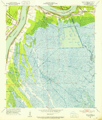
1951 Map of Belle Chasse
USGS Topo · Published 1952About this map
The Mississippi River creates a dramatic curve at Twelvemile Point, defining the mid-century industrial and transit corridor south of New Orleans. This landscape is a complex network of man-made waterways and rail infrastructure, where the U.S. Government Railroad and Missouri Pacific lines converge near Belle Chasse. Along the river's eastern bank, small settlements like Braithwaite and Scarsdale sit perched on narrow strips of firm ground, separated from the interior marsh by the Forty Arpent Canal. The eastern half of the quadrangle dissolves into the sprawling wetlands of Big Mar and Lake Lery, threaded by natural features like Cane Ridge Slough and Tigers Chenes. Strategic river-front facilities, including the Sea Train Terminal and US Naval Reservation, highlight the area's maritime importance during the post-war era.
Find a feature on this map
33 named features on this map. Tap any name to fly to it.
Don’t see what you’re looking for? This feature index may not catch every label — zoom into the map to look around manually.
Map Details
Editions of this 1951 Belle Chasse Map
2 editions found
Other maps of this area

1891 · Pointe a La Hache
USGS Topo · 1:62,500

1891 · New Orleans
USGS Topo · 1:62,500

1892 · Barataria
USGS Topo · 1:62,500

1892 · St. Bernard
USGS Topo · 1:62,500

1892 · Pointe a La Hache
USGS Topo · 1:62,500

1932 · New Orleans NE
USGS Topo · 1:31,680

1932 · New Orleans SE
USGS Topo · 1:31,680

1935 · Delacroix
USGS Topo · 1:31,680

1935 · Lake Batola
USGS Topo · 1:31,680
1939 · New Orleans East
USGS Topo · 1:31,680