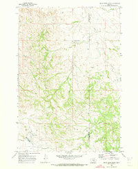
1970 Map of Belle Creek North
USGS Topo · Published 1973About this map
The town of Belle Creek serves as a remote hub of petroleum extraction along the southern edge of this Montana landscape. At the time of this 1970 field check, the community is defined by its industrial infrastructure, including a cluster of Oil Wells, a prominent Water Tank, and specialized Sewage Disposal Ponds required for its operations. A Landing Strip suggests the necessity of air travel for reaching this high plains outpost in the southeast corner of the state.
Find a feature on this map
14 named features on this map. Tap any name to fly to it.
Don’t see what you’re looking for? This feature index may not catch every label — zoom into the map to look around manually.
Map Details
Editions of this 1970 Belle Creek North Map
This is the sole edition of this map. No revisions or reprints were ever made.
Other maps of this area

1954 · Ekalaka
USGS Topo · 1:250,000

1956 · Ekalaka
USGS Topo · 1:250,000

1958 · Ekalaka
USGS Topo · 1:250,000

1965 · Ekalaka
USGS Topo · 1:250,000

1970 · Sanburn Reservoir
USGS Topo · 1:24,000
1970 · Belle Creek South
USGS Topo · 1:24,000

1970 · Belle Creek SW
USGS Topo · 1:24,000
1970 · Stack Rocks
USGS Topo · 1:24,000
1970 · Hammond
USGS Topo · 1:24,000

1980 · Broadus
USGS Topo · 1:100,000