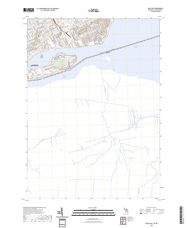
2023 Map of Belle Isle
USGS Topo · Published 2023About this map
Belle Isle sits prominently in the Detroit River as a major public landscape in this 2023 survey. This map shows the island's intricate network of inland water bodies including Lake Muskoday, Lake Okonoka, and Lake Tacoma, which are separated from the main Fleming Channel and Scott Middle Ground. On the northern shore, the residential and industrial street grid of Detroit is well-defined, showing the layout of historical corridors like E Jefferson Ave and Lafayette St E. The map also captures the international boundary as it passes through Lake Saint Clair toward Windmill Point. The contrast between the organized urban blocks and the park-like terrain of the island illustrates the long-standing commitment to urban recreational space in this region. Further south, the natural hydrology remains visible through drainage patterns like Little River and Turkey Creek as they approach the Detroit River system.
Find a feature on this map
104 named features on this map. Tap any name to fly to it.
Don’t see what you’re looking for? This feature index may not catch every label — zoom into the map to look around manually.
Map Details
Editions of this 2023 Belle Isle Map
This is the sole edition of this map. No revisions or reprints were ever made.
Other maps of this area

1905 · Detroit
USGS Topo · 1:62,500

1905 · Grosse Pointe
USGS Topo · 1:62,500

1906 · Wyandotte
USGS Topo · 1:62,500

1912 · Wyandotte
USGS Topo · 1:62,500

1918 · Detroit
USGS Topo · 1:62,500

1918 · Grosse Pointe
USGS Topo · 1:62,500

1924 · Detroit
USGS Topo · 1:62,500

1929 · Wyandotte
USGS Topo · 1:62,500

1934 · Detroit
USGS Topo · 1:62,500
1936 · Highland Park
USGS Topo · 1:31,680