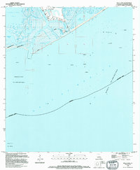
1994 Map of Belle Pass
USGS Topo · Published 1994About this map
Port Fourchon stands as the primary industrial hub on this coastal reach, serving as a critical jumping-off point for offshore energy operations in the Gulf of Mexico. The landscape is dominated by the convergence of Bayou Lafourche and Belle Pass, where a dense network of oil tanks, heliports, and platforms illustrates the intensive maritime and industrial infrastructure required by the surrounding oil and gas fields. Coastal engineering is evident in the prominent Seawall and various submerged pipelines that traverse the marshy inlets. This 1994 survey captures the area after significant development, showing how the natural hydrology of Timbalier Bay and Bay Champagne has been integrated with the commercial demands of the Block 2 Oil and Gas Field. The map provides a detailed look at the interface between the fragile wetlands of Lafourche Parish and the heavy industrial footprint of the petroleum industry during the late twentieth century.
Find a feature on this map
21 named features on this map. Tap any name to fly to it.
Don’t see what you’re looking for? This feature index may not catch every label — zoom into the map to look around manually.
Map Details
Editions of this 1994 Belle Pass Map
This is the sole edition of this map. No revisions or reprints were ever made.
Other maps of this area

1892 · Cheniere Caminada
USGS Topo · 1:62,500

1894 · Timbalier
USGS Topo · 1:62,500

1935 · Pelican Pass
USGS Topo · 1:31,680

1935 · Calumet Island
USGS Topo · 1:31,680

1935 · Leeville
USGS Topo · 1:31,680

1945 · New Orleans
USGS Topo · 1:250,000

1945 · Leeville
USGS Topo · 1:31,680

1947 · Caminada Pass
USGS Topo · 1:31,680
1949 · Belle Pass
USGS Topo · 1:31,680
1953 · Belle Pass
USGS Topo · 1:24,000