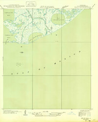
1949 Map of Belle Pass
USGS Topo · Published 1949About this map
Bayou Lafourche and its outlet into the Gulf of Mexico dominate this coastal landscape, which was compiled from aerial photography just as the mid-century era began. This advance sheet captures the intricate lattice of marshes and inlets where the bayou meets Belle Pass. The settlement of Belle sits near the western shoreline, adjacent to Raccoon Pass and the open waters of Timbalier Bay. The map provides a detailed view of the natural and engineered hydrology of the Louisiana coast, including the circular Bay Champagne and the Evans Canal. These features illustrate the precarious transition between the mainland wetlands and the open gulf, showing the area before decades of significant coastal erosion altered the shape of Bay Marchand and the surrounding barrier-island landforms.
Find a feature on this map
11 named features on this map. Tap any name to fly to it.
Don’t see what you’re looking for? This feature index may not catch every label — zoom into the map to look around manually.
Map Details
Editions of this 1949 Belle Pass Map
This is the sole edition of this map. No revisions or reprints were ever made.
Other maps of this area

1892 · Cheniere Caminada
USGS Topo · 1:62,500

1894 · Timbalier
USGS Topo · 1:62,500

1935 · Pelican Pass
USGS Topo · 1:31,680

1935 · Calumet Island
USGS Topo · 1:31,680

1935 · Leeville
USGS Topo · 1:31,680

1945 · New Orleans
USGS Topo · 1:250,000

1945 · Leeville
USGS Topo · 1:31,680

1947 · Caminada Pass
USGS Topo · 1:31,680
1953 · Belle Pass
USGS Topo · 1:24,000
1953 · Calumet Island
USGS Topo · 1:24,000