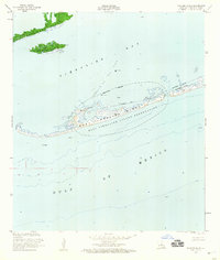
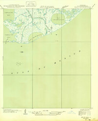
1953 Map of Calumet Island
USGS Topo · Published 1959About this map
East Timbalier Island and its surrounding coastal waters define this mid-century survey of the Louisiana shoreline. The landscape is dominated by the East Timbalier Island Reservation, a fragile barrier landform separating the open Gulf of Mexico from the interior waters of Timbalier Bay. This 1950s record captures the region's industrial infrastructure during the expansion of offshore extraction, notably within the Timbalier Bay Oil Field. Dozens of wells, oil tanks, and a network of submerged pipelines are meticulously charted across the bay and island interior. Navigational markers such as a daybeacon and light provide essential orientation for the era's maritime traffic. Nearby landmasses like Calumet Island and Brush Island appear as small, isolated points of marsh and terrain in an environment increasingly shaped by both natural tides and resource development.
Find a feature on this map
14 named features on this map. Tap any name to fly to it.
Don’t see what you’re looking for? This feature index may not catch every label — zoom into the map to look around manually.
Map Details
Editions of this 1953 Calumet Island Map
4 editions found
Other maps of this area

1892 · Cheniere Caminada
USGS Topo · 1:62,500

1894 · Timbalier
USGS Topo · 1:62,500

1935 · Timbalier Island
USGS Topo · 1:31,680

1935 · Pelican Pass
USGS Topo · 1:31,680

1935 · Calumet Island
USGS Topo · 1:31,680

1935 · Leeville
USGS Topo · 1:31,680

1945 · New Orleans
USGS Topo · 1:250,000

1945 · Leeville
USGS Topo · 1:31,680

1947 · Jacko Bay
USGS Topo · 1:31,680
1949 · Belle Pass
USGS Topo · 1:31,680