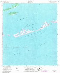
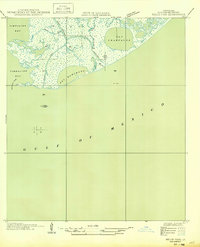
1953 Map of Calumet Island
USGS Topo · Published 1986About this map
East Timbalier Island and the surrounding marshy archipelagos of Timbalier Bay dominate this coastal survey. The landscape is defined by the tension between wildlife conservation and industrial expansion during the mid-20th century, particularly within the East Timbalier Island Reservation. Infrastructure for the Timbalier Bay Oil Field is prominent, featuring a complex network of pipelines, submerged pipelines, and numerous oil tanks. To the north, Casse-Tete Island and Calumet Island provide a clear view of the fragmented shoreline before modern erosion and subsidence further altered the Louisiana coast. This sheet illustrates the specific mid-century period when remote offshore wells and storage tanks began to populate the waters of the Gulf of Mexico, mapping a geography where navigable waterways and industrial utility intersect.
Find a feature on this map
19 named features on this map. Tap any name to fly to it.
Don’t see what you’re looking for? This feature index may not catch every label — zoom into the map to look around manually.
Map Details
Editions of this 1953 Calumet Island Map
4 editions found
Other maps of this area

1892 · Cheniere Caminada
USGS Topo · 1:62,500

1894 · Timbalier
USGS Topo · 1:62,500

1935 · Timbalier Island
USGS Topo · 1:31,680

1935 · Pelican Pass
USGS Topo · 1:31,680

1935 · Calumet Island
USGS Topo · 1:31,680

1935 · Leeville
USGS Topo · 1:31,680

1945 · New Orleans
USGS Topo · 1:250,000

1945 · Leeville
USGS Topo · 1:31,680

1947 · Jacko Bay
USGS Topo · 1:31,680
1949 · Belle Pass
USGS Topo · 1:31,680