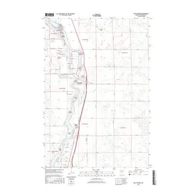
2016 Map of Belle Prairie
USGS Topo · Published 2016About this map
The Mississippi River carves a complex course through this portion of Morrison County, defining a landscape of numbered and named islands such as Island Thirty-seven and Ducette Island. West of the river, the Ray S. Miller Army Airfield and a dense network of military roads like Chickamauga Rd and Tank Trail signal the presence of a significant installation. The settlement of Belle Prairie sits just south of Camp Ripley Junction, serving as a focal point for local history with the Holy Family Church Cemetery. To the east, the terrain transitions to a series of wetlands and glacial features, notably the Ripley Esker. This 2016 survey captures the intersection of military infrastructure and the natural riverine environment, providing a detailed look at the modern layout of cemetery sites, including the Minnesota State Veterans Cemetery and Green Prairie Cemetery.
Find a feature on this map
110 named features on this map. Tap any name to fly to it.
Don’t see what you’re looking for? This feature index may not catch every label — zoom into the map to look around manually.
Map Details
Editions of this 2016 Belle Prairie Map
This is the sole edition of this map. No revisions or reprints were ever made.
Other maps of this area

1948 · Belle Prairie
USGS Topo · 1:62,500

1948 · Pierz
USGS Topo · 1:62,500

1948 · Lastrup
USGS Topo · 1:62,500

1948 · Little Falls
USGS Topo · 1:62,500

1950 · Lastrup
USGS Topo · 1:62,500

1950 · Belle Prairie
USGS Topo · 1:62,500

1950 · Little Falls
USGS Topo · 1:62,500

1950 · Pierz
USGS Topo · 1:62,500

1953 · Brainerd
USGS Topo · 1:250,000

1953 · Saint Cloud
USGS Topo · 1:250,000