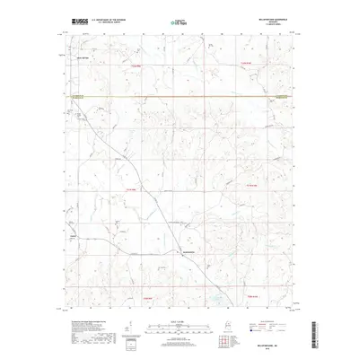
2018 Map of Bellefontaine
USGS Topo · Published 2018About this map
Bellefontaine and the surrounding Webster County countryside are defined by a network of rural roads and creek drainages in this modern survey. The terrain is marked by the dividing line between Calhoun and Webster counties, with small settlements like Slate Springs and Embry serving as local anchors. For those tracing family histories, the map provides a high density of burial sites, including North Union Cemetery, Vance Cemetery, and Spring Hill Cemetery. These sites, often located near local thoroughfares like N Union Cemetery Rd, offer spatial context for the area's genealogical record. The landscape is naturally shaped by watercourses such as Sabougla Creek and Shutispear Creek, while Dorroh Lake serves as a notable local landmark. Infrastructure like the American Legion post and various county roads illustrate the continued community layout of this Mississippi region.
Find a feature on this map
59 named features on this map. Tap any name to fly to it.
Don’t see what you’re looking for? This feature index may not catch every label — zoom into the map to look around manually.
Map Details
Editions of this 2018 Bellefontaine Map
This is the sole edition of this map. No revisions or reprints were ever made.
Other maps of this area

1953 · Walthall
USGS Topo · 1:62,500

1953 · West Point
USGS Topo · 1:250,000

1954 · Pittsboro
USGS Topo · 1:62,500

1958 · West Point
USGS Topo · 1:250,000

1963 · West Point
USGS Topo · 1:250,000

1972 · Atlanta
USGS Topo · 1:24,000

1972 · Sapa
USGS Topo · 1:24,000

1972 · Hohenlinden
USGS Topo · 1:24,000
1976 · Pittsboro SE
USGS Topo · 1:24,000
1976 · Walthall SE
USGS Topo · 1:24,000