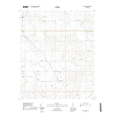
2020 Map of Bellefontaine
USGS Topo · Published 2020About this map
Bellefontaine and the surrounding woodlands of Webster and Calhoun counties are defined by a complex network of creeks and rural cemeteries. The landscape is carved by the meandering paths of Sabougla Cr, Shutispear Cr, and Bellefontaine Cr, which drain the low-lying basins of the region. Small, longstanding communities like Slate Springs and Embry are connected by a web of county roads including Macon Rd and Dorroh Rd. Genealogists and local historians will find significant value in the high density of burial sites documented here, such as North Union Cem, Pilgrim Rest Cem, and the family-named Vance Cem. The presence of landmarks like Dorroh Lake and the American Legion post reflect the social and recreational focal points of this quiet corner of Mississippi during the early twenty-first century.
Find a feature on this map
62 named features on this map. Tap any name to fly to it.
Don’t see what you’re looking for? This feature index may not catch every label — zoom into the map to look around manually.
Map Details
Editions of this 2020 Bellefontaine Map
This is the sole edition of this map. No revisions or reprints were ever made.
Other maps of this area

1953 · Walthall
USGS Topo · 1:62,500

1953 · West Point
USGS Topo · 1:250,000

1954 · Pittsboro
USGS Topo · 1:62,500

1958 · West Point
USGS Topo · 1:250,000

1963 · West Point
USGS Topo · 1:250,000

1972 · Atlanta
USGS Topo · 1:24,000

1972 · Sapa
USGS Topo · 1:24,000

1972 · Hohenlinden
USGS Topo · 1:24,000
1976 · Pittsboro SE
USGS Topo · 1:24,000
1976 · Walthall SE
USGS Topo · 1:24,000