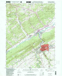
1998 Map of Bellefonte
USGS Topo · Published 1999About this map
Bellefonte serves as the focal point of this late-century survey, revealing the dense urban core and its industrial periphery at the confluence of Spring Creek and Logan Branch. The landscape is dominated by the massive ridge of Bald Eagle Mountain, which separates the main valley from the smaller settlements of Milesburg and Wingate. The map documents a complex mix of civic infrastructure and industry, including the Rockview State Correctional Institution and numerous extractive sites labeled as Quarry and Strip Mine. Genealogists and local historians can locate several important burial grounds, such as Union Cem and Trcziyulny Cem, alongside rural landmarks like the Advent Ch. The presence of an Old Railroad Grade and Run Railroad Grade illustrates the evolution of transport in Centre County, while isolated spots like Fishermans Paradise highlight the area's recreational geography.
Find a feature on this map
66 named features on this map. Tap any name to fly to it.
Don’t see what you’re looking for? This feature index may not catch every label — zoom into the map to look around manually.
Map Details
Editions of this 1998 Bellefonte Map
This is the sole edition of this map. No revisions or reprints were ever made.
Other maps of this area

1908 · Bellefonte
USGS Topo · 1:62,500

1909 · Bellefonte
USGS Topo · 1:62,500

1921 · Howard
USGS Topo · 1:48,000

1923 · Howard
USGS Topo · 1:62,500

1924 · Centre Hall
USGS Topo · 1:62,500

1928 · Snow Shoe
USGS Topo · 1:48,000

1929 · Centre Hall
USGS Topo · 1:62,500

1931 · Show Shoe
USGS Topo · 1:62,500

1943 · Lewistown
USGS Topo · 1:125,000

1950 · Harrisburg
USGS Topo · 1:250,000