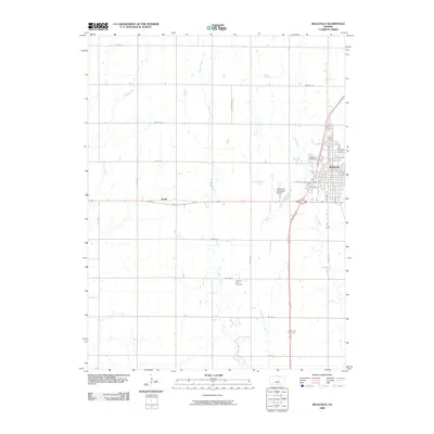
2009 Map of Belleville
USGS Topo · Published 2009About this map
Belleville serves as the primary hub of this North Central Kansas landscape, defined by a rigid grid of agricultural roads and the winding paths of West Creek and School Creek. The town is meticulously detailed, showing a dense street network including 7th St through 13th St, and the outlying Belleville Municipal Airport. This 2009 survey highlights the geographic relationship between the main town and the smaller community of Rydal to the west. For those researching local heritage, several significant burial grounds are documented, including Belleville Cemetery on the town's northern edge, Pleasant View Cemetery situated near the center of the quadrangle, and Grace Hill Cemetery to the south. The map illustrates how transportation corridors like Lincoln Rd and various county roads, such as Co Rd M and Co Rd S, connect these rural settlements and cemeteries across the Republican County terrain.
Find a feature on this map
45 named features on this map. Tap any name to fly to it.
Don’t see what you’re looking for? This feature index may not catch every label — zoom into the map to look around manually.
Map Details
Editions of this 2009 Belleville Map
This is the sole edition of this map. No revisions or reprints were ever made.
Other maps of this area

1892 · Concordia
USGS Topo · 1:125,000

1955 · Manhattan
USGS Topo · 1:250,000

1956 · Manhattan
USGS Topo · 1:250,000

1957 · Manhattan
USGS Topo · 1:250,000

1965 · Wayne
USGS Topo · 1:24,000

1965 · Concordia NW
USGS Topo · 1:24,000

1965 · Kackley
USGS Topo · 1:24,000

1966 · Scandia
USGS Topo · 1:24,000
1966 · Belleville SE
USGS Topo · 1:24,000
1966 · Belleville
USGS Topo · 1:24,000