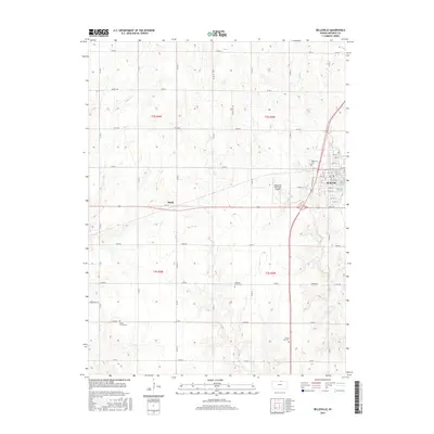
2015 Map of Belleville
USGS Topo · Published 2015About this map
Belleville serves as the primary hub of this Republic County landscape, where the intersection of US Hwy 36 and several county roads anchors a grid of agricultural land. The town’s layout is documented in detail, showing a clear urban core transition into surrounding farmland, supported by the Belleville Municipal Airport to the south. Smaller named locales like Rydal represent the modest rural settlements that dot the plains of North Central Kansas.
Find a feature on this map
56 named features on this map. Tap any name to fly to it.
Don’t see what you’re looking for? This feature index may not catch every label — zoom into the map to look around manually.
Map Details
Editions of this 2015 Belleville Map
This is the sole edition of this map. No revisions or reprints were ever made.
Other maps of this area

1892 · Concordia
USGS Topo · 1:125,000

1955 · Manhattan
USGS Topo · 1:250,000

1956 · Manhattan
USGS Topo · 1:250,000

1957 · Manhattan
USGS Topo · 1:250,000

1965 · Wayne
USGS Topo · 1:24,000

1965 · Concordia NW
USGS Topo · 1:24,000

1965 · Kackley
USGS Topo · 1:24,000

1966 · Scandia
USGS Topo · 1:24,000
1966 · Belleville SE
USGS Topo · 1:24,000
1966 · Belleville
USGS Topo · 1:24,000