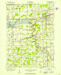
1952 Map of Belleville
USGS Topo · Published 1953About this map
Belleville Lake and the winding Huron River anchor this mid-century survey of western Wayne County. The landscape is a transition between the established lakeside community of Belleville and the developing transportation corridors to the east near Romulus. High-speed travel is already well-defined by the Willow Run Expressway and the Detroit Industrial Expressway, while the Wabash RR and Chesapeake and Ohio RR maintain the region's industrial backbone. Away from the major arteries, small settlements like New Boston and Martinsville retain their rural character, marked by numerous local drain systems like Apple Run and Savage Drain that feed the river valley. The map is particularly useful for genealogists, identifying several local landmarks including Hillside Cem, St Stephens Cem, and the Mt Pleasant Sch, offering a precise look at the township before later suburban expansion.
Find a feature on this map
80 named features on this map. Tap any name to fly to it.
Don’t see what you’re looking for? This feature index may not catch every label — zoom into the map to look around manually.
Map Details
Editions of this 1952 Belleville Map
Other maps of this area

1902 · South Lyon
USGS Topo · 1:62,500

1902 · Ypsilanti
USGS Topo · 1:62,500

1904 · Ann Arbor
USGS Topo · 1:125,000

1905 · Wayne
USGS Topo · 1:62,500

1906 · Ypsilanti
USGS Topo · 1:62,500

1906 · South Lyon
USGS Topo · 1:62,500

1906 · Romulus
USGS Topo · 1:62,500

1908 · Ann Arbor
USGS Topo · 1:125,000

1912 · Wayne
USGS Topo · 1:62,500

1928 · Romulus
USGS Topo · 1:62,500
Featured Places
- Van Buren Charter Township, MI
- Romulus, MI
- Huron Charter Township, MI
- Sumpter Township, MI
- Belleville, MI