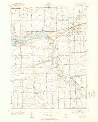
1952 Map of Belleville
USGS Topo · Published 1953About this map
Belleville Lake and the winding Huron River dominate this early 1950s landscape, illustrating a region in the midst of post-war transformation. While the Wabash RR and Chesapeake and Ohio RR maintain the traditional rail-oriented transport patterns of older towns like Belleville and New Boston, the emergence of the Willow Run Expressway and Detroit Industrial Expressway signals the accelerating shift toward the modern automotive age. In the surrounding townships of Van Buren and Romulus, small crossroads and rural schoolhouses such as East Tyler Sch and Sumpter Sch sit alongside growing residential clusters like Little Farms. For those researching family ties, the map identifies several local burial grounds including Martinsville Cem and Otisville Cem, providing exact spatial context for these community landmarks before the full suburban expansion of the later twentieth century.
Find a feature on this map
85 named features on this map. Tap any name to fly to it.
Don’t see what you’re looking for? This feature index may not catch every label — zoom into the map to look around manually.
Map Details
Editions of this 1952 Belleville Map
Other maps of this area

1902 · South Lyon
USGS Topo · 1:62,500

1902 · Ypsilanti
USGS Topo · 1:62,500

1904 · Ann Arbor
USGS Topo · 1:125,000

1905 · Wayne
USGS Topo · 1:62,500

1906 · Ypsilanti
USGS Topo · 1:62,500

1906 · South Lyon
USGS Topo · 1:62,500

1906 · Romulus
USGS Topo · 1:62,500

1908 · Ann Arbor
USGS Topo · 1:125,000

1912 · Wayne
USGS Topo · 1:62,500

1928 · Romulus
USGS Topo · 1:62,500
Featured Places
- Van Buren Charter Township, MI
- Romulus, MI
- Huron Charter Township, MI
- Sumpter Township, MI
- Belleville, MI