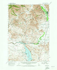
1957 Map of Bellevue
USGS Topo · Published 1973About this map
Mining operations and agricultural development define the Wood River Valley in the late 1950s. The town of Bellevue and the nearby settlement of Broadford serve as the primary hubs for the region, positioned along the Big Wood River and the Union Pacific railroad line. The landscape is heavily marked by its mineral wealth, with numerous tunnels, shafts, and named operations like the Minnie Moore Mine, Red Elephant Mine, and SR Silver Star Queen Mine dotting the surrounding hills. To the south, the waters of the Magic Reservoir dominate the terrain, creating a transition from the industrial character of the northern mines to a recreational and ranching landscape. Scattered ranching outposts such as Rowley Ranch and Stewart Ranch are linked by rural routes and unique crossings like the Swinging Bridge and Stanton Crossing, while landmarks such as Glendale Sch and Timmerman Cem provide important reference points for local genealogy.
Find a feature on this map
105 named features on this map. Tap any name to fly to it.
Don’t see what you’re looking for? This feature index may not catch every label — zoom into the map to look around manually.
Map Details
Editions of this 1957 Bellevue Map
2 editions found
Other maps of this area

1895 · Hailey
USGS Topo · 1:125,000

1897 · Hailey
USGS Topo · 1:125,000

1900 · Sawtooth
USGS Topo · 1:125,000

1955 · Hailey
USGS Topo · 1:250,000

1957 · Thorn Creek
USGS Topo · 1:62,500

1957 · Bellevue
USGS Topo · 1:62,500

1957 · Blaine
USGS Topo · 1:62,500

1957 · Bellevue
USGS Topo · 1:24,000

1959 · Hailey
USGS Topo · 1:250,000

1962 · Hailey
USGS Topo · 1:250,000