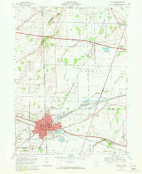
1969 Map of Bellevue
USGS Topo · Published 1971About this map
The industrial and rail hub of Bellevue dominates this landscape at the junction of several major transportation corridors. Located at the intersection of the Norfolk and Western and Penn Central railroads, the city shows a dense network of residential streets and civic institutions, including the McKim Sch, Ellis Sch, and a local Hospital. A significant historical marker is the Connecticut Western Reserve Boundary, which bisects the quadrangle, reflecting early Ohio land divisions. Outside the urban center, the terrain is characterized by scattered rural settlements such as Strongs Ridge and Parkertown, along with family-associated landmarks like Graves Cem and Tew Cem. The presence of a Quarry and Gravel Pit near the city limits indicates the area's geological utility, while the modern path of the Ohio Turnpike cuts across the northern landscape near Mills Creek.
Find a feature on this map
52 named features on this map. Tap any name to fly to it.
Don’t see what you’re looking for? This feature index may not catch every label — zoom into the map to look around manually.
Map Details
Editions of this 1969 Bellevue Map
4 editions found
Other maps of this area

1901 · Bellevue
USGS Topo · 1:62,500

1903 · Bellevue
USGS Topo · 1:62,500

1904 · Sandusky
USGS Topo · 1:62,500

1915 · Norwalk
USGS Topo · 1:62,500

1915 · Siam
USGS Topo · 1:62,500

1944 · Norwalk
USGS Topo · 1:62,500

1956 · Toledo
USGS Topo · 1:250,000

1957 · Vickery
USGS Topo · 1:24,000

1959 · Kimball
USGS Topo · 1:24,000

1959 · Sandusky
USGS Topo · 1:24,000