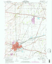
1969 Map of Bellevue
USGS Topo · Published 1979About this map
Bellevue straddles the intersection of several northern Ohio counties, serving as a critical rail hub for the Norfolk and Western lines. The urban center is densely packed with community institutions including the McKim Sch, Ellis Sch, and a hospital, while the Bellevue Cem defines the southern corporate boundary. Beyond the city limits, the landscape transitions into a grid of agricultural townships like Groton and Lyme, where the Ohio Toll Road Turnpike cuts a modern path across older corridors like Portland Road.
Find a feature on this map
60 named features on this map. Tap any name to fly to it.
Don’t see what you’re looking for? This feature index may not catch every label — zoom into the map to look around manually.
Map Details
Editions of this 1969 Bellevue Map
4 editions found
Other maps of this area

1901 · Bellevue
USGS Topo · 1:62,500

1903 · Bellevue
USGS Topo · 1:62,500

1904 · Sandusky
USGS Topo · 1:62,500

1915 · Norwalk
USGS Topo · 1:62,500

1915 · Siam
USGS Topo · 1:62,500

1944 · Norwalk
USGS Topo · 1:62,500

1956 · Toledo
USGS Topo · 1:250,000

1957 · Vickery
USGS Topo · 1:24,000

1959 · Kimball
USGS Topo · 1:24,000

1959 · Sandusky
USGS Topo · 1:24,000