
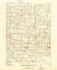
1915 Map of Siam
USGS Topo · Published 1936About this map
Siam and Attica serve as central hubs in this early twentieth-century depiction of the agricultural borderland between Seneca and Huron counties. The landscape is defined by an intricate network of drainage ditches, such as Royer Ditch and Armstrong and Beighley Ditch, which converted the naturally wet terrain into productive farmland. This drainage effort is punctuated by the remnants of the West Boundary Connecticut Reserve, a significant historical survey line that influences the local road grid and township divisions.
Find a feature on this map
88 named features on this map. Tap any name to fly to it.
Don’t see what you’re looking for? This feature index may not catch every label — zoom into the map to look around manually.
Map Details
Editions of this 1915 Siam Map
2 editions found
Other maps of this area

1901 · Bellevue
USGS Topo · 1:62,500

1901 · Fremont
USGS Topo · 1:62,500

1903 · Bellevue
USGS Topo · 1:62,500

1903 · Fremont
USGS Topo · 1:62,500

1904 · Sandusky
USGS Topo · 1:62,500

1906 · Sycamore
USGS Topo · 1:62,500

1906 · Tiffin
USGS Topo · 1:62,500

1915 · Norwalk
USGS Topo · 1:62,500

1915 · Bucyrus
USGS Topo · 1:62,500

1915 · Crestline
USGS Topo · 1:62,500