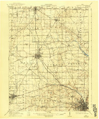
1915 Map of Crestline
USGS Topo · Published 1943About this map
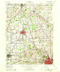
The South Boundary Connecticut Reserve runs across the northern reaches of this landscape, a significant cadastral line dividing Huron and Richland counties. This era reveals a dense network of steam and electric transport, with the Pennsylvania RR and Baltimore and Ohio RR converging at industrial hubs like Shelby and the rail junction of Crestline. The rural landscape between these centers is partitioned into townships like Blooming Grove and Sharon, marked by a high density of local institutions including Hazel Brush School and Kuhn School.
Find a feature on this map
77 named features on this map. Tap any name to fly to it.
Don’t see what you’re looking for? This feature index may not catch every label — zoom into the map to look around manually.
Map Details
Editions of this 1915 Crestline Map
This is the sole edition of this map. No revisions or reprints were ever made.
Historical Maps of Mansfield Through Time
8 maps found