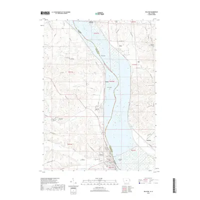
2018 Map of Bellevue
USGS Topo · Published 2018About this map
The Mississippi River carves a deep valley between Iowa and Illinois, defining the character of this riverfront landscape near the city of Bellevue. On the Iowa side, the terrain is marked by high ridges and winding creeks such as Spruce Cr and Mill Cr, where early settlement patterns are still visible through numerous family and church burial grounds. Notable sites include Daugherty Farm Cem and Federman Farms Cem, alongside the prominent Saint Nicholas Catholic Cem. Across the water in Illinois, the landscape transitions into the steep bluffs of Pilot Knob and the low-lying reaches of Beaty Hollow near Blanding. The river itself is dotted with large islands like Scott Island and Hale Island, while the eastern bank is home to small rail-oriented locales like Galena Junction and Aiken. This map offers a clear view of the complex road network, from Sieverding Ridge Rd to Smiths Ferry Rd, connecting these river communities.
Find a feature on this map
92 named features on this map. Tap any name to fly to it.
Don’t see what you’re looking for? This feature index may not catch every label — zoom into the map to look around manually.
Map Details
Editions of this 2018 Bellevue Map
This is the sole edition of this map. No revisions or reprints were ever made.
Other maps of this area

1891 · Maquoketa
USGS Topo · 1:62,500

1901 · Peosta
USGS Topo · 1:125,000

1911 · Galena
USGS Topo · 1:62,500

1913 · Galena
USGS Topo · 1:62,500

1935 · East Dubuque
USGS Topo · 1:62,500

1935 · Miles
USGS Topo · 1:62,500

1940 · East Dubuque
USGS Topo · 1:62,500

1941 · Miles
USGS Topo · 1:62,500

1953 · Green Island
USGS Topo · 1:24,000

1955 · Menominee
USGS Topo · 1:24,000