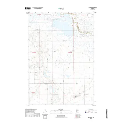
2019 Map of Bellingham
USGS Topo · Published 2019About this map
Bellingham anchors the southern portion of this west-central Minnesota landscape, situated at the crossroads of a section-line road network that defines the region's agricultural character. The topography is dominated by the winding course of the Yellow Bank River and the S Fork Yellow Bank River, which carve subtle drainage patterns through the prairie toward the Minnesota River in the northeast. For genealogists and local historians, the map provides precise locations for several rural burial grounds, including Yellow Bank Cem, Immanuel Cem, and Salem Cem. These sites, alongside Saint Pauls Cem and the Bellingham Cem, serve as primary markers of the area's early settlement history. The presence of Mud Lake and surrounding wetlands highlights the natural hydrology that persists alongside a century of drainage and cultivation in Lac qui Parle County.
Find a feature on this map
32 named features on this map. Tap any name to fly to it.
Don’t see what you’re looking for? This feature index may not catch every label — zoom into the map to look around manually.
Map Details
Editions of this 2019 Bellingham Map
This is the sole edition of this map. No revisions or reprints were ever made.
Other maps of this area

1953 · Ortonville
USGS Topo · 1:62,500

1953 · Bellingham
USGS Topo · 1:62,500

1953 · Milbank
USGS Topo · 1:250,000

1958 · Milbank
USGS Topo · 1:250,000

1958 · Madison
USGS Topo · 1:24,000

1958 · Correll
USGS Topo · 1:24,000

1968 · Artichoke Lake
USGS Topo · 1:24,000

1971 · Odessa
USGS Topo · 1:24,000

1971 · Marietta
USGS Topo · 1:24,000
1971 · Haydenville
USGS Topo · 1:24,000