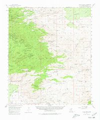
1957 Map of Bellota Ranch
USGS Topo · Published 1980About this map
Bellota Ranch and the surrounding Pima County canyons are documented here during a period of active land use in the late 1950s. The landscape is marked by a history of mineral exploration and cattle ranching, with the Geesaman Mine Group, Daly Mine Group, and Leatherwood Mine Group clustered near Marble Peak. The transition from the high peaks of the Santa Catalina Mountains down to the basins is evident, where scattered water sources like Poppy Well Wash and Peck Spring supported the remote Youtcy Ranch and Agua Caliente Ranch.
Find a feature on this map
104 named features on this map. Tap any name to fly to it.
Don’t see what you’re looking for? This feature index may not catch every label — zoom into the map to look around manually.
Map Details
Editions of this 1957 Bellota Ranch Map
4 editions found

Other maps of this area

1904 · Tucson
USGS Topo · 1:125,000

1905 · Tucson
USGS Topo · 1:125,000

1911 · Winkelman
USGS Topo · 1:125,000

1913 · Winkelman
USGS Topo · 1:125,000

1938 · Galiuro Mts
USGS Topo · 1:48,000

1943 · Galiuro Mts
USGS Topo · 1:62,500

1945 · Redington
USGS Topo · 1:62,500

1945 · Happy Valley
USGS Topo · 1:62,500

1948 · Tucson
USGS Topo · 1:62,500

1948 · Mammoth
USGS Topo · 1:62,500