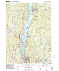
1998 Map of Bellows Falls
USGS Topo · Published 2002About this map
The Connecticut River serves as the central artery for this border region, separating the industrial centers of Bellows Falls and North Walpole at the southern edge of the sheet. This late 20th-century landscape is defined by its deep valley orientation, where the Boston and Maine rail lines and various state highways parallel the water, connecting settlements like South Charlestown and Drewsville. The terrain rises sharply from the riverbanks to prominent overlooks like Fall Mountain and Oak Ridge, while the Bellows Falls Village Forest preserves substantial woodland along the western hills.
Find a feature on this map
87 named features on this map. Tap any name to fly to it.
Don’t see what you’re looking for? This feature index may not catch every label — zoom into the map to look around manually.
Map Details
Editions of this 1998 Bellows Falls Map
This is the sole edition of this map. No revisions or reprints were ever made.
Other maps of this area

1926 · Claremont
USGS Topo · 1:62,500

1927 · Bellows Falls
USGS Topo · 1:48,000

1928 · Ludlow
USGS Topo · 1:48,000

1929 · Claremont
USGS Topo · 1:62,500

1929 · Ludlow
USGS Topo · 1:62,500

1930 · Saxtons River
USGS Topo · 1:48,000

1930 · Bellows Falls
USGS Topo · 1:62,500

1932 · Ludlow
USGS Topo · 1:62,500

1933 · Saxtons River
USGS Topo · 1:62,500

1950 · Glens Falls
USGS Topo · 1:250,000